
A Historic El Niño Is Coming. Gedo Has Weeks.
Forecasters give it a greater than 90 per cent chance of becoming a very strong event, and a 69 per cent chance of being the strongest measured since 1950. The last one displaced 1.2 million Somalis. This page sets out what is coming, what it does to people, and what Lifeline Gedo is building right now to stop it.
What the Forecasters Are Saying
Four independent bodies — the ocean forecasters, the regional climate centre, the food security network and the Somali government — are giving the same warning at the same time. That agreement is unusual, and it is why we are acting now rather than waiting.
The 2023 Floods Are the Benchmark, Not the Worst Case
The 2023 Deyr floods were driven by the last El Niño. The one now forecast is projected to be stronger, and it arrives with communities that have not recovered from it.
A Flood Is Not One Disaster. It Is Nine.
In Gedo the damage runs in a sequence, and each stage makes the next one worse. This is the chain our engineering works are designed to break, and it is drawn from what our own teams recorded in Bardhere and Belet Hawa after 2023.
1. The rivers rise before the sky changes
Rain in the Ethiopian highlands feeds the Juba and the Dawa. Water arrives in Gedo days after it fell, often while local conditions still look calm, so communities lose the warning time they would otherwise have.
2. Silted channels overflow at lower levels than before
Every flood deposits sediment. The Kurman Valley channel through Bardhere town carries far less water than it did before 2023, so today even ordinary seasonal rain spills into the settlement. Each event makes the next one worse. The channel does not recover on its own.
LLG technical assessment, Kurman Valley, July 2026
3. The market floods first
Bardhere's main market sits beside the channel. Water in the market destroys traders' stock and stops the daily income that thousands of households depend on for food. The homes closest to the channel, in the most densely occupied plots in town, are hit at the same moment.
4. Crossings block, and the town splits in two
Debris carried by the flood jams the bridge openings, backs water up behind them and loads the structures until they fail, as happened in April 2023. Kurman and Bandar sit on the opposite side of the valley from the main market and the town's health facilities. When the crossings go, roughly 8,000 households lose access to food and medical care for as long as the water stands.
5. Evacuation routes become impassable
The roads people would use to reach high ground are unsurfaced and undrained. Water stands on them, cuts into them, and after each flood they are in worse condition than before. The western neighbourhoods of Bardhere — about 30,000 people — are left without a reliable way out at the moment they most need to move.
6. Safe water fails exactly when it is needed most
The shallow wells supplying Belet Hawa town sit on the Dawa floodplain, none of them on high ground. Floodwater submerges the wellheads, fills the wells with silt and contaminates the water column. Water trucking to the town stops and village piped systems fail at the same moment that every other source is contaminated.
LLG technical assessment, Malkariyey, Oda and Gawiido wells, July 2026
7. Standing water breeds disease
Water left behind after each event creates breeding conditions for mosquitoes and raises the risk of waterborne disease in dense settlements. Cholera and malaria follow floods in Gedo as reliably as the floods follow the rain — and they arrive when clean water has just been lost and clinics have just become unreachable.
8. The harvest is destroyed, so the hunger comes later
Floodwater takes the standing crop, the seed stock and the topsoil, and leaves sand behind. The household does not go hungry in the week of the flood. It goes hungry in the season that should have followed it, which is why flood emergencies turn into food emergencies months after the water has gone.
9. Families that have nothing left move
The end of the chain is displacement. Households that lose farm, herd and income at once leave for the displacement sites around Bardhere and Dollow — the same sites that FEWS NET now identifies as being at credible risk of Famine between October and January.
So What Is Lifeline Gedo Doing About It?
Not planning to respond after the water comes. Building before it does. Under the AARAN programme — Advancing Adaptation through Resilient Mobility and Natural Capital — our engineers surveyed five sites across Bardhere and Belet Hawa districts in June and July 2026, and produced five full technical assessments with structural calculations, drawing sets and measured bills of quantities. Every one is designed to be built with plant, materials and labour already available in Gedo, and to be finished in the dry window before the Deyr rains arrive.
Five Works, Designed and Ready to Build
Each of these addresses one specific link in the chain above. Together they protect the market, the crossings, the evacuation route and the water supply of two districts.
Kurman Valley Channel Desilting
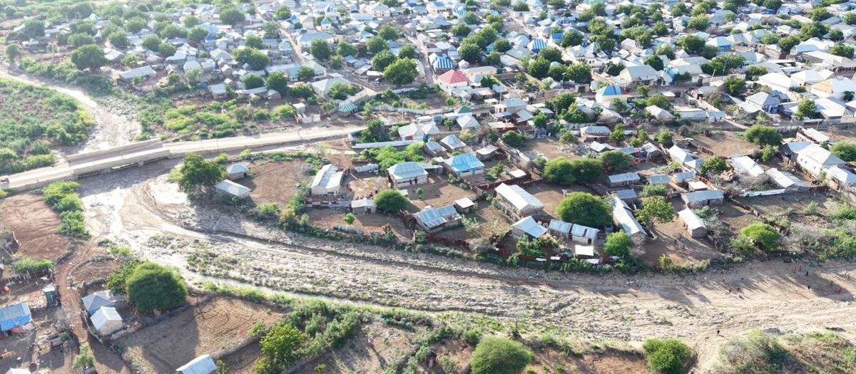
The Kurman Valley carries flash runoff from the Wirawira catchment through the middle of Bardhere to the Juba River. The 2023 El Niño rains filled it with eroded soil, raising the bed and flattening its gradient, so the channel now overflows into the market and the homes of Kurman and Bandar during ordinary seasonal rain.
We are excavating a one-kilometre reach back to a uniform trapezoidal section with a continuous fall to the river, restoring roughly 10 cubic metres per second of capacity and protecting the Wadada Sako crossing within the reach. Four plant units, all sourced in Bardhere, complete the cut in about 27 working days.
Aarjino Valley Embankment Rehabilitation
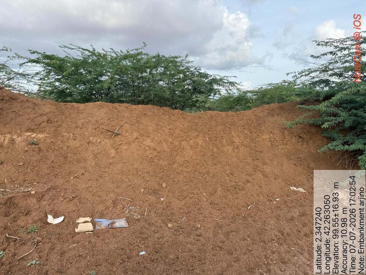
The Aarjino embankment holds floodwater out of the settled ground behind it. Successive flood events have breached it in a number of places, and every breach is a door the next flood walks through. Water that the embankment was built to turn away now enters at the failures and spreads behind the defence.
We are reconstructing the breached sections to the original profile — a 1.5 metre crest on a 6 metre base, two metres high, tied into the sound embankment either side of each failure — so the line holds continuously along its full length before the rains.
Mardha Bridge
At Mardha a gravel access road crosses a seasonal valley draining to the Juba. There is no structure there at all, so every flood closes the road — and with it the route that Mardha, Shimbirole West, Sarinley, Bula-arab and more than ten other villages use to reach the markets, clinics and schools of Bardhere town, and to move their produce to sell.
We are building a single-span reinforced concrete bridge with nothing standing in the channel, so flood and debris pass beneath the deck instead of piling against it. The foundations are taken 2.5 metres below the channel bed, well below the depth the water is expected to erode.
Suuqyare Road — Flood Evacuation Route
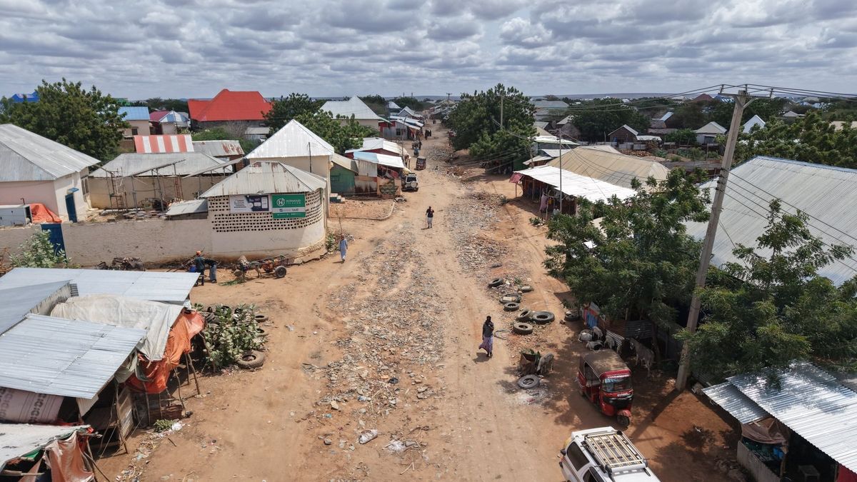
The Suuqyare road runs through the middle of Suuqyare market and is the main route serving the western neighbourhoods behind it. It is the road these households use to reach higher ground when the Juba rises — and in its present state, an unformed earth and rock track with no shape, no gravel and no drainage, it fails at precisely the moment it is needed.
We are rebuilding it as a properly shaped gravel road with earth side drains falling continuously to an outfall, designed to carry the heavy trucks that supply the market and to stay passable through the flood season. The corridor between the shops is only seven metres wide, so the carriageway and both drains are designed to fit inside it exactly, and the works are staged in short sections so the market never closes.
Flood Protection of Four Shallow Wells
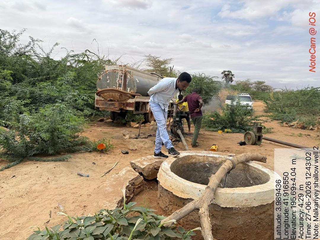
Four shallow wells on the Dawa floodplain are the principal water source for Belet Hawa town and the surrounding villages. Two of them fill 8,000 litre bowsers up to six times a day for water trucking into the town; the other two feed village piped systems through solar pumping. All four already hold between 2.2 and 3.3 metres of silt, and their headworks are cracked or open.
We are desilting each well back to its original hard bottom and building a raised, sealed, double-wall wellhead designed on the assumption that the site floods completely — so floodwater is kept out of the water column even when the structure is submerged. Works are staged one well at a time so trucking to the town never stops.
This Is What We Could Design. It Is Not What Gedo Needs.
These five works are assessed, engineered, drawn and priced. They can be built with plant and labour already in Gedo, and they can be finished before the rains — but only if mobilisation happens now. Every week of delay moves the works closer to the season they are meant to beat.
They also cover five sites. Gedo has twelve districts, hundreds of kilometres of riverine settlement along the Juba and the Dawa, dozens of unprotected water points and scores of crossings that close with every flood. What is designed here is a demonstration of what locally-led anticipatory action looks like when it is done properly. It is not the full scale of what the region requires, and we are seeking partners to extend it.
Building Before the Water Comes Costs Less Than Rescuing After It
Somalia's 2026 Humanitarian Needs and Response Plan stood at 11.3 per cent funded in March. In an underfunded year, the case for acting on a forecast rather than on damage is not only humanitarian, it is financial. Desilting a channel before a flood costs a fraction of feeding, treating and resettling the households that channel would otherwise displace — and it keeps the market trading, the clinic reachable and the water clean, which is the difference between a difficult season and a famine.
Lifeline Gedo has worked in Gedo continuously since 2005. Our engineers surveyed these sites themselves, our field teams recorded the 2023 damage in the same villages, and the works are designed to be built by people who live there. That is what locally-led adaptation means in practice.
The Rains Begin in October
Everything on this page has to be finished before then.